Cookie Consent by Free Privacy Policy Generator
South Yorkshire Safer Roads Partnership
Welcome to the Data Portal
Here you can find information about road traffic collisions across South Yorkshire as well as the casualties involved.

Data on road traffic collisions and casualties, known as STATS19 data, are recorded by police forces across Great Britain and are fed centrally to the DfT. South Yorkshire Police share these data with the South Yorkshire Safer Roads Partnership central team and our partners. We then use the data to inform interventions and engineering schemes that make our roads safer for everyone who uses them.

The STATS19 database does not hold information about every collision that happens on our roads. Following national protocol, a collision will only be recorded if;

  • It resulted in injury to one or more of the participants (excluding death due to natural causes or confirmed suicide) 
  • It involved at least one vehicle (this includes non-motorised vehicles such as pedal cycles or ridden horses) 
  • It commenced on public highway – those maintained by one of the four districts of South Yorkshire or the motorways and trunk roads maintained by Highways England 
  • It is reported to the police within 30 days of occurring

STATS19 data represent the most complete set of data about road traffic collisions that involve personal injury in Great Britain and include information on circumstances surrounding the collision, the vehicles involved and casualties that have occurred as a result. Every reasonable effort is made to ensure that STATS19 data are correct. The data is validated at the local level by the police and the Safer Roads Partnership central team before being checked again at year end by the DfT. Through these checks most errors can be identified and corrected. In spite of this, inaccuracies can occur and the accuracy of the information provided cannot be guaranteed.

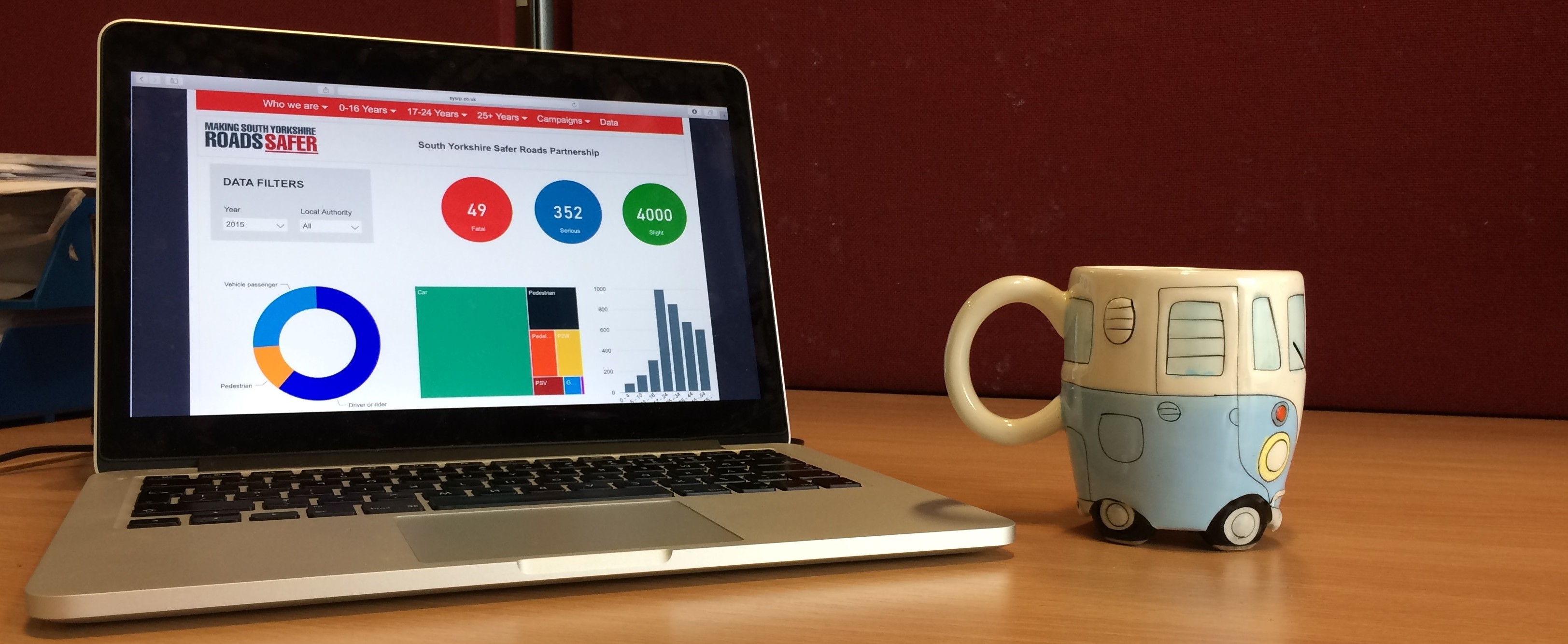
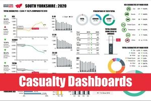
Information about the casualties involved in collisions can be found by using the casualty dashboard link below. Our collision map contains information about the location of collisions on roads around South Yorkshire. For common queries about STATS19 data see our FAQs below. For more technical information, the STATS20 document outlines all variables recorded in STATS19 and gives guidance on how to record them. Information about collisions outside of South Yorkshire can be found on the National Collision Map. If you have any other questions feel free to contact us.

Frequently asked questions
Police forces across Great Britain record information about road traffic collisions and casualties in their area – this is known as STATS19 data. South Yorkshire Police collect these data and supply them locally to the Safer Roads Partnership, as well as to central government. STATS19 data do not capture all collisions. Specifically, accidents that should not be reported include: accidents which do not involve personal injury, accidents on private roads (except Royal Parks) or in car parks, accidents reported to the police 30 or more days after they occurred and accidents involving confirmed suicides only. Collisions that should be recorded, as stipulated by The Road Traffic Act 1988 (section 170), as amended by Section 72 of the 1991 Act include all fatal or injury accidents on public roads involving at least one mechanically propelled vehicle. This includes all accidents involving non-motor vehicles such as pedal cycles and ridden horses on 'public roads', regardless of motor vehicle or pedestrian involvement.
STATS19 data is released only once a complete year is agreed and closed centrally by the DfT. This usually occurs mid-way through the following year but can take longer as the data is subject to rigorous validation processes to ensure the quality and accuracy. Until this point the data is considered provisional and is subject to change. Only once this process is complete will the latest available data be published here.
Examples of serious injury include: Broken neck or back, Severe head injury, Severe chest injury, Internal injuries, Loss of arm or leg, Fracture, Deep cuts/lacerations, Burns (excluding friction burns),Concussion, Detention in hospital as an in-patient, either immediately or later, Injuries to casualties who die 30 or more days after the accident from injuries sustained in that accident. Examples of slight injury include: Whiplash or neck pain, Shallow cuts/lacerations, Sprains and strains, Bruising, Slight shock requiring roadside attention. A single road traffic collision may include a number of casualties. The overall severity of the collision is determined by the highest severity casualty
The collision may not have been reported to South Yorkshire Police or may not have been recorded if it was reported 30 or more days following the collision. The collision may not have resulted in personal injury and although it may have been recorded by South Yorkshire Police, it will not have been supplied to the Safer Roads Partnership or to the DfT. The collision may not have commenced on the public highway. The collision may have been inaccurately recorded resulting in an inaccurate plot. Every effort is made to ensure that the data is correct but accuracy cannot always be guaranteed.
Road accident and safety statistics are available from the DfT and to find out about collisions elsewhere in Great Britain visit the National Collision Map.

For further information about SYSRP and our campaigns and initiatives, or if you have any queries, then contact us using this form or drop an email to enquiries@sysrp.co.uk.

To keep up-to-date with our many events and initiatives around South Yorkshire then follow us @SYSaferRoads.


facebook-sign.jpg     Logo-instagram-(1).png     twitter-sign.jpg        


Is there anything wrong with this page? Let us know.

Privacy